DERG CASTLE 22-11-2014
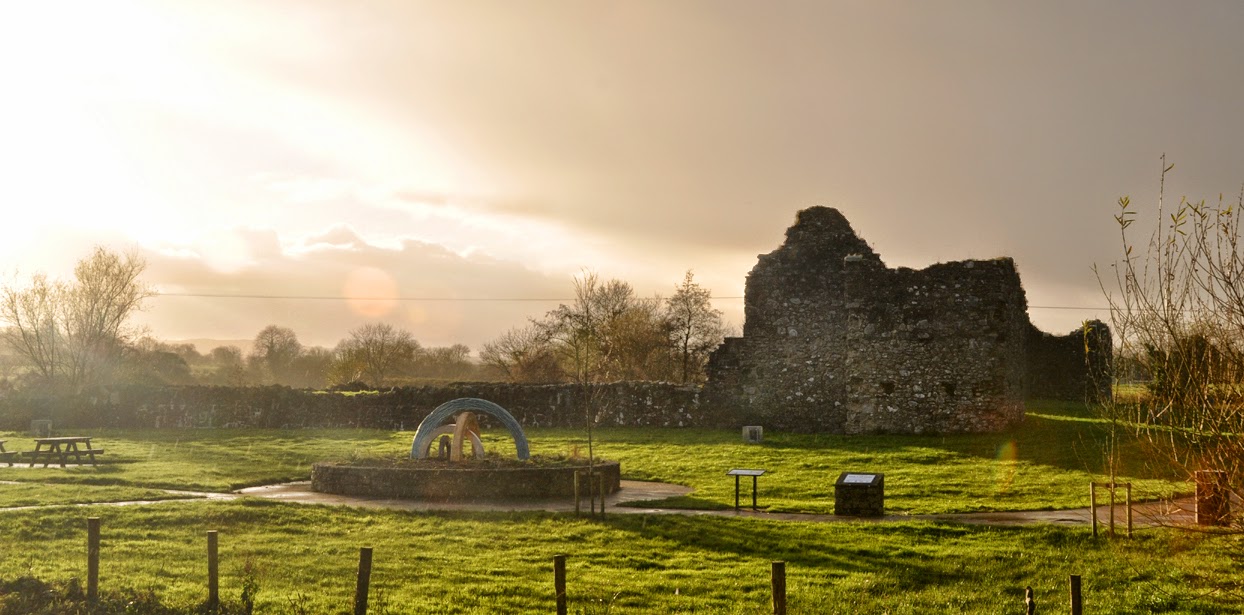 |
| E side of Castle Derg, as seen from the entrance to the park, with the sun setting. |
 |
| public information |
Sunday morning began early for me, a fine, bright,
frosty Sunday at that, i headed off to Aghyaran, Co. Tyrone for Volleyball
practice with Spikers, its bitter and i can hardly see the road the sun is so low and bright. The morning before saw me driving to Dungannon in similar conditions, this time to the seat of O'Neill power in Ulster for the O'Neill Historical Societies journal No. 22 launch. But today i am in contested zone between the clans of Tír Chonaill and Tír Eoghain.
So as the practice venue was close
to Castlederg, i decided it would good to have the camera ready my SD cards clean and if i get the chance weather permitting i might get to view the Castle. I dont know how many times, i thought of this site, over the years but with one thing and another it never happened, so was my chance. The previous day after the book launch i made an unsuccessful attempt to see Tullyhogue and with day light abating i had to turn west for Tír Chonaill, so i wasn't going to be denied two days in a row. The day wasnt without its problems, the ground was very wet and the sun was bright and low thus silhouetting some of the shots annoyingly, so it was a bit hit (as can be seen in the photos) but this would be my best chance before next spring.
The Castle
This was
a fairly important late medieval/early modern fortification (strategically) being on the ford of the
Derg river being a boundary between contested Lords of old Tír Eoghain and Tír Chonaill, as such many a hard blow was dealt and received for its control over this small piece of land over the centuries.
 |
| Derg Castle public information |
So i drove from Aghyaran into Castlederg town and followed the signage which took me into the car park behind the Derg Arms public house. Once i got my bearings, i saw that the Castle was nicely developed into a public park with amenities for children to enjoy. There was an information board next the Car park which gives you basic info on the general area, history and about the Castle (pics included).
Castle View Park
As i walked towards the Castle i saw a really nice wrought iron gate with symbolism for peace and reconciliation, along with other tasteful sculptures. When you enter through the gate one is struck by the fairly intact structure, which is the centre piece of the park, with public sculptures, seating, paths and in the distance a playground for children all done in a way that in no way takes away from the castle remains. Off the path is fairly wet (so wear proper shoes) and the Derg river is within a few meters of the southern wall of the castle (see below).
 |
| the fording point on the Derg river, from inside the SE flanker |
The first feature i wanted to look at was the river (above) and see where the modern bridge is in relationship to the fort & ford. it was interesting to note there is still a fording point next the castle (above), this is on a gentle bend and in fact one can still see large stones in the water (possible stepping stones). At Scarrifollus outside Letterkenny there are 2 fording points with stepping stones on both sides of the horse shoe bend in the river where the Castle was built so controlling both crossing points. Anyway's I digress....
 |
| looking into the SE flanker, nearest the ford looking towards the new bridge. |
 |
| looking west along the southern wall & up the Derg river (note the bend) viewed from SE flanker |
The Castle
The present fortification’s remains, are essentially 17th century phase of construction, if the information is
correct. The fortification, has a bawn (walled
enclosure) typical of plantation period in Ulster, but how much of it comes from the early phase is the real question?
 |
| looking SE at N wall of the bawn |
The bawn is rectangular running north south towards the river, it has a 3 remaining flanker towers at each
corner (one was washed away by the floods) and a the remnants of a house inside the enclosure (one gable remain’s). There seems to have been a moat or ditch also but i am not sure if this is part of the fortifications or some other feature such as a sunken causeway? I assume its a ditch. In its day this must
have been an impressive building in comparison to the
indigenous structures and that of the later early colonists to the area under Sir John Davies.
 |
| W wall, showing the NW flanker |
According to the “tourist information”
the remains of the original tower house c. 1490s (which predates the present structure) was located during the 1991 archaeological dig. this structure was situated in the centre of the present bawn. Which is interesting and i wonder if like Donegal Castle that there was a curtain wall around the tower house as they dont mention any other footings from this earlier period? So i wonder if the north wall and flankers are part of this phase of buildings and the house was added later?
 |
| N wall looking S |
When one is standing inside the bawn area, you
can clearly see the hummocks and hollows of previous occupation, so the archaeological report would be an
interesting read. They also found 3 bodies near the entrance, with buckles and
coinage these date to the Nine years war period. Although the present structure is very much attributed to the period of Sir John Davies and later.
 |
| interior of N wall and NW flanker from inside the bawn, showing loops and joist holes for hoarding (walkway?). |
These structures were made with shelter and defense in mind, so usually they had a fortified house/building, with a defensive bawn. These are
mentioned in Pynnar's Survey. It seems then that following the “wars in Ireland
(1594-1603)” and subsequent “flight of the Earls (1607)” Davies received land
with an extant or existing structures, which he rebuilt or reinforced, probably
using the existing stone from the tower house to do so.
 |
| the SE flanker with S, E & largely intact N wall with loops |
In some
areas such as the Finn Valley, you can still see the older system of forts guarding the crossing points, these Cashels (circular
stone enclosures) and earthen forts (rath) still dot the OS maps as red circles on both sides of the river valley. One large Líos exists at Clonclayagh near Cloghan overlooking the Finn is as big in diameter as Grianain Aileach, but many smaller earthen enclosures which zig zag the river Finn as testament to the importance of controlling the crossings and access to them.
 |
| looking NW, this is the SE flanker tower |
But Sir John Davies never completed this fortification, so one must assume the castle was further developed after his time, as military outpost and as a
refuge for the colonists in times of strife. It would serve this use when Sir Phelim O'Neill unsuccessfully besieged the castle in 1641. The garrison however handed the castle over control to the Army of James II during the Williamite
wars (1688-91). Following this period the castle seems to have gone out of use?
the hamster in the wheel...
For me, i cant help wondering how much of the present
structure is a remnant of the original Tower house and associated structures?? These
sometimes had substantial curtain walls, towers, flankers and outworks such as
moats, roads, paths, causeways i.e. Donegal Castle, Enniskillen, Doe etc..
 |
| the NW flanker (centre) N and W walls from inside the bawn area |
 | ||
| inside the main gate,to the left is an oven |
Its interesting that the first mention of a castle here at this site is
mentioned a few decades after Donegal Castle was constructed 1474. So one could
speculate that this was part of a system of fortifications/strongpoints to control access into Tír Chonaill and counter O’Neill
expansion before the policy of bridge building by the English administration in the 18th century.
 |
| NE flanker, the main entrance & remaining gable of the house |
happy clicking?
I took photos of views which i felt were relevant, obviously i cant post everything, so I've put up some images which might give an overall impression of the site. If you get a chance do visit the sites its interesting. But definitely for me the relationship
between the crossing point (still visible) and the fortification is vital to understanding the rationale for these structures, it illustrates a real concern by the Gaelic
chiefs in protecting the integrity of their territories, when they went to the expense and trouble to construct and man these installations. With their defeat and the coming of bridges the land became joined up and so the natural physical separations and the need to defend them was nullified.
 |
| loophole with original stone cover NW flanker |
 |
| loop-hole on the E flanker 1st storey, this covers the S approach |


Comments
Post a Comment